
vfo-knob-adsb
The ADS-B Radar firmware
vfo-knob-adsb turns the knob into a radar of the aircraft round you. North
is up, the middle is a place you choose, and the dial sets the range. The
aircraft come from an ADS-B feed on the internet, or from a receiver of your
own. Each is an arrow along its track, coloured by its altitude and labelled
with its callsign and level. An emergency is called out in red, and a type
you watch for in gold. Tap an aircraft for its card, with its route.
It is after Alex-developer's ADSB-Radar: the same feeds, fields and colours, drawn on the knob's round glass.
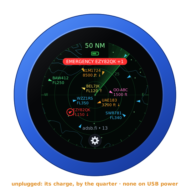
The pictures are the knob's own screens; the orange marks are what your hand does.
First run
Install it from the setup firmware's list (ADS-B Radar), or under Firmware on any firmware's configuration page — see the setup guide. The knob needs WiFi with a way to the internet, or to your own receiver.
Out of the box the middle is Brussels Airport, EBBR, and the aircraft
come from adsb.fi: once the knob is on WiFi, the radar shows what flies
round Brussels. To make it yours, open the knob's configuration page: tap
the gear for the address card, and browse to the address on it. The user is
admin and the password admin. The page first asks for a password of the
knob's own, 8 to 32 characters, and shows nothing else until it has one.
Under Radar:
| Setting | |
|---|---|
| Middle | an airport by its ICAO code (EBBR), from the knob's own list of the large and medium ones; or a place, its latitude and longitude in degrees, north and east positive — your station's, say. Left empty: EBBR |
| Aircraft from | adsb.fi until set, adsb.lol or airplanes.live — free, no key needed — or your own receiver |
| Your receiver's address | readsb's, dump1090's or tar1090's: http://192.168.1.20/tar1090; /data/aircraft.json is added when there is no path |
| Distances in | nautical miles, kilometres or miles |
| Show | every aircraft; military aircraft; or interesting ones, as the feed's database marks them |
| Asked every | 5 to 60 seconds; 10 until set |
| Airports, Coasts and borders, The sweep | on until turned off |
| Aircraft on the ground | off until turned on |
| Call out these types | ICAO type codes, by comma or space: A400, C17, B74* — a * for every type starting so |
Save, and the radar shows it at once. The page has no audio and no Bluetooth for this firmware: the knob has no sound to give here.
The face
| Part | ||
|---|---|---|
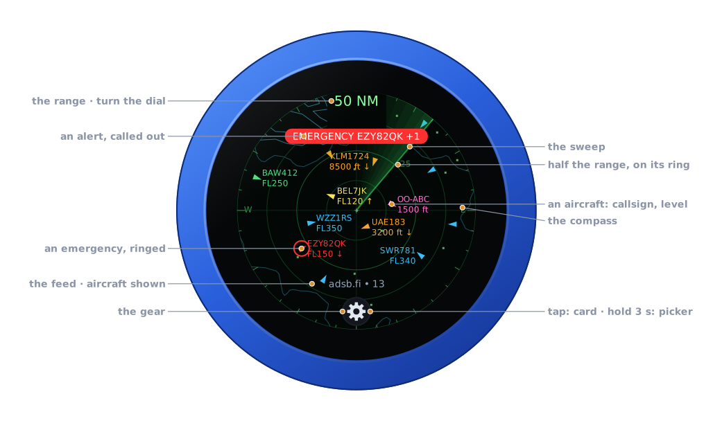
| The range | turn the dial | across the radar, edge to edge from the middle: 50 NM; MIL or INT beside it with the filter on |
| The rings | — | a quarter, half and three quarters of the range; half of it written on its ring |
| The compass | — | a tick each 10°, longer every 30° and 90°; E and W at the edge |
| The map | — | coasts and borders, and the airports as dots, the nearest named where there is room |
| The aircraft | tap: its card | arrows along their track, labelled nearest first where there is room |
| The banner | — | an emergency, or a type on your list: what, and which; +2 for more |
| The sweep | — | goes round every 3.6 s, as on a radar's screen |
| The feed | — | where the aircraft come from, and how many are on the radar; what went wrong, in amber |
| The gear | tap: the address card · hold 3 s: the firmware picker | see The gear |
| Battery | — | the knob's own, under the range, while it runs on it |
There is no PTT, and no swipe does anything: the whole glass is the radar's.
The range
Turn the knob: the next range, a detent each, with a click. In nautical miles or miles: 5, 10, 20, 30, 50, 75, 100, 150, 200 and 250. In kilometres: 10, 20, 40, 60, 100, 150, 200, 300, 400 and 450. The dial holds at either end.
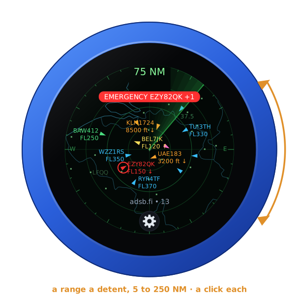
The map follows at once. Once the dial has rested for 0.6 s the knob keeps that range and asks the feed for it straight away. After a restart the range is where you left it.
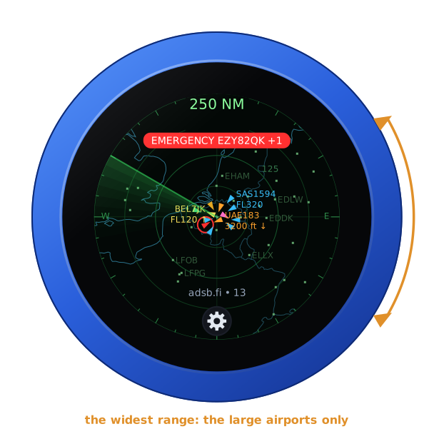
Past 100 NM, the map shows the large airports alone:
The aircraft
Each aircraft is an arrow pointing along its track, or a small square when the feed has no track for it. Its colour is its altitude:
| Altitude | Colour |
|---|---|
| on the ground, or none given | grey |
| under 2,000 ft | pink |
| under 10,000 ft | orange |
| under 20,000 ft | yellow |
| under 30,000 ft | green |
| under 40,000 ft | blue |
| 40,000 ft and up | violet |
| an emergency | red, with a red ring |
| a type on your list | gold |
The twelve nearest are labelled where there is room: the callsign (else the registration, else the ICAO address), and the level — a flight level from 10,000 ft up, else feet — with an arrow when it climbs or descends more than 300 ft a minute. A label never covers another, nor the range, the banner or the foot. An aircraft whose position is more than 20 s old is drawn dimmer. Aircraft on the ground are left out unless the page asks for them.
An aircraft's card
Tap an aircraft: its card. It shows the callsign, the type and registration, the route, the level with its rate of climb or descent, the speed and track, where it is from the middle, and its squawk. The aircraft is ringed in white, and the sweep waits while the card is up.
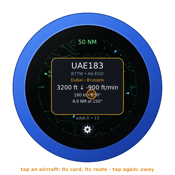
The route comes from adsbdb, looked up by the callsign the first time a card shows it (route ... while it is asked). The knob keeps the last sixteen. An aircraft without a callsign, or one adsbdb does not know, has no route.
Tap the card, or anywhere away from an aircraft, and it goes. On its own it goes after 20 s, or when the aircraft leaves the feed.
Alerts
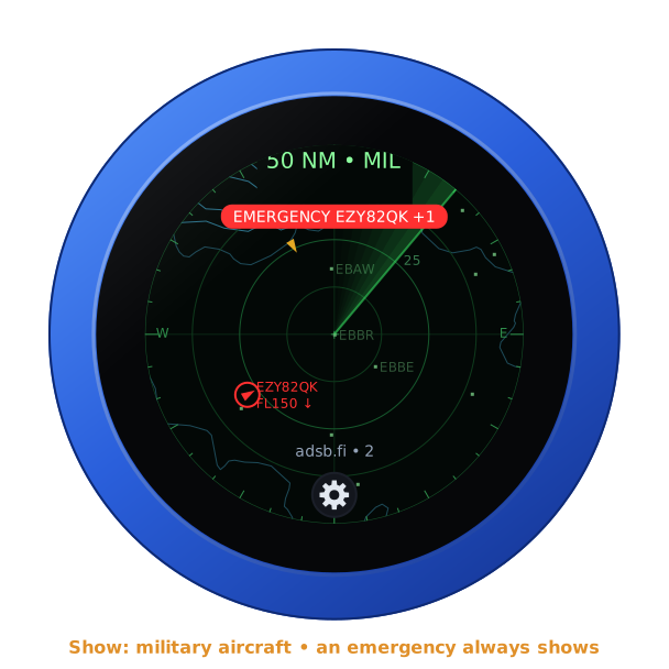
An emergency — a squawk of 7500, 7600 or 7700, or the feed's own emergency — is always shown, whatever the filter. It is red, ringed in red, and called out at the top: EMERGENCY, HIJACK, NO RADIO, MEDICAL, MINIMUM FUEL or DOWNED, with its callsign. The knob buzzes once when one comes into range.
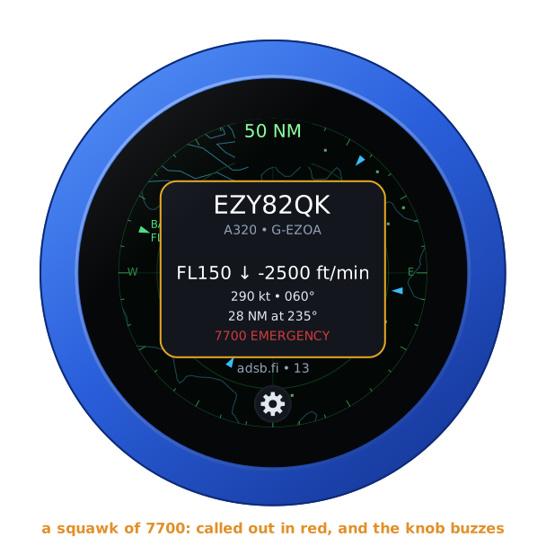
A type on your list (Call out these types) is gold, shown whatever the filter, and called out at the top in gold on brown. The knob clicks once when one comes into range. An emergency outranks a type in the banner; +1, +2 and so on count the other alerts on the radar.
Show
Military aircraft or interesting aircraft shows those alone, as the feed's database marks them; an emergency and a type on your list still show. The range says which: 50 NM · MIL, 50 NM · INT.
The feeds
The three sites gather what receivers all over the world hear, and each answers for the aircraft within the range of the middle; 250 NM is their limit. airplanes.live answers HTTP 403 until its people have been written to (contact@airplanes.live, with what the project is); adsb.fi and adsb.lol answer anyone. The knob asks every 10 seconds unless set otherwise, and at once when the range or the settings change. While a feed fails, its foot says why (HTTP 429, no answer, no WiFi) in amber, and the last aircraft stay on the radar.
Your own receiver — readsb, dump1090 or tar1090 — is asked for its
aircraft.json, the whole of it; the knob keeps the 300 nearest within the
range.
The gear
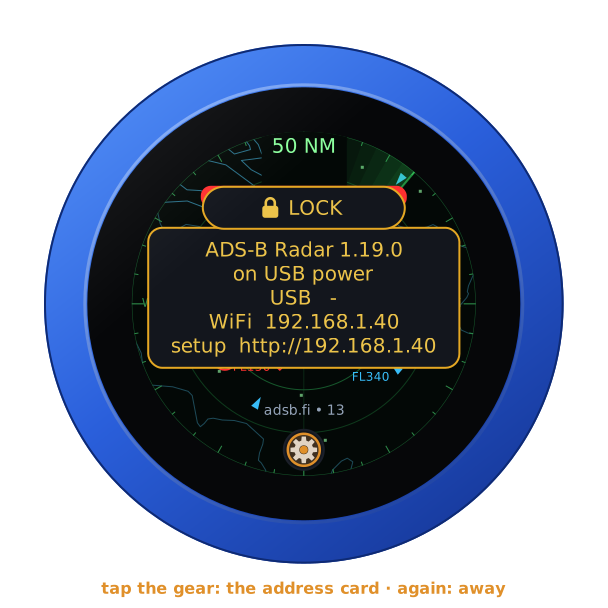
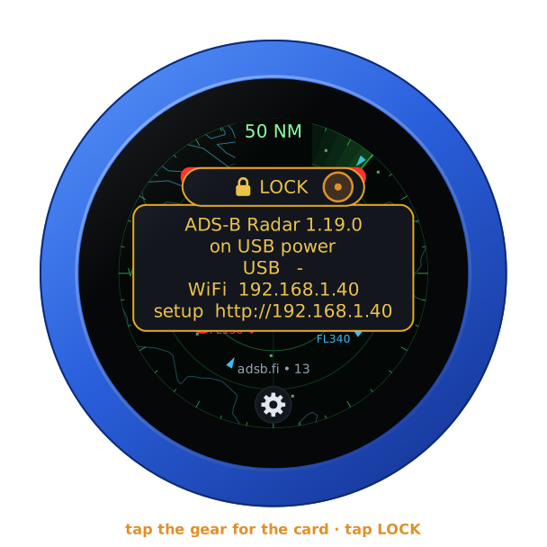
Tap the gear: the address card, with the firmware and its version, the knob's power, and its addresses for the configuration page. Tap the gear again, or the card itself, and it goes; on its own it goes after ten seconds.
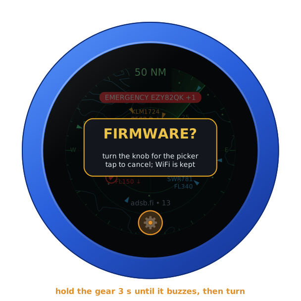
Hold the gear for three seconds, until the knob buzzes: it asks FIRMWARE?. Turn the knob for yes, and it restarts into the setup firmware's list, to install another firmware. A tap, or ten seconds of nothing, says no.
On its own battery
Unplugged, the knob shows its charge under the range, as a phone does: full to empty by the quarter, green from half its charge up, yellow under that, red at a fifth and below. On USB power the charge cannot be read, and none shows. The map leaves the top clear for it.
The lock
The address card carries LOCK, as on every firmware: tap it, and the knob is locked.
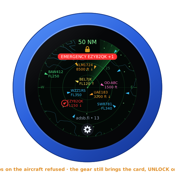
Locked, the padlock shows under the range. The dial and a tap on an aircraft then do nothing, and the range stays where it is. The gear still brings the card, with UNLOCK on it. A restart unlocks the knob too.
Where it comes from
- The feeds, their fields and the altitude colours: Alex-developer's ADSB-Radar, MIT, forked as Guru-RF/ADSB-Radar.
- The aircraft: adsb.fi, adsb.lol and airplanes.live, or your own receiver.
- The routes: adsbdb.
- The map: Natural Earth's coastlines
and land borders, and OurAirports' large and
medium airports — both public domain, in the knob's image
(
tools/adsb_tables.py).